
What Is Geofencing? How It Works & Real Examples
Geofencing is a location-based technology that creates a virtual boundary around a real-world geographic area and triggers an action when a connected device enters, exits, or remains inside that boundary. Businesses, mobile applications, fleet operators, smart-home systems, advertisers, and security teams use geofencing to automate experiences based on location. A geofence could surround a retail store, warehouse, school, construction site, delivery zone, neighborhood, stadium, or even a much larger region. When an authorized smartphone, vehicle tracker, wearable, or other connected device crosses that digital boundary, the system can send a notification, record an event, change a setting, or start another automated process. Technologies such as GPS, Wi-Fi, cellular networks, Bluetooth, and RFID can contribute to location detection depending on the application. In simple terms, geofencing connects digital actions with movement through physical locations.
Geofencing has become especially useful as smartphones, connected vehicles, cloud applications, and Internet of Things devices have become more location-aware. A retailer might send an opted-in customer a promotion when they arrive near a store, while a logistics company might automatically mark a delivery vehicle as arriving at a warehouse. A parent could receive an alert when a family device reaches a predefined location, and a smart-home application might adjust compatible devices when the homeowner approaches the property. Organizations can also use geofencing for asset management, workforce operations, security, and location-based marketing. However, location data can be sensitive, so permission, transparency, data minimization, and appropriate security are important parts of responsible implementation. Understanding how geofencing works makes it easier to recognize both its practical benefits and its privacy implications.
What Is Geofencing?
Geofencing is the process of defining a digital perimeter around a physical location and using software to detect when a device interacts with that perimeter. The boundary is called a geofence and can usually be represented by a circle, polygon, route, or another geographic shape on a digital map. Once the boundary is created, a location-enabled application or tracking system compares a device’s position with the coordinates defining the area. Entering or leaving the zone can then create an event that other software responds to automatically. The event itself might be simple, such as recording an arrival time, or more complex, such as launching a marketing workflow. Geofencing therefore acts as a bridge between geographic movement and digital automation.
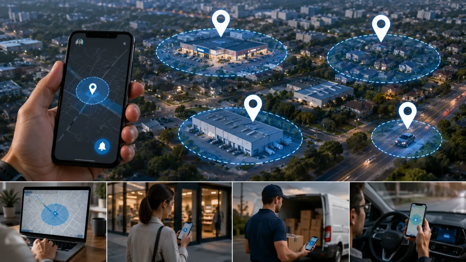
A basic geofence might be created by choosing a central location and assigning a radius around it. For example, a coffee shop could define a virtual boundary extending several hundred meters around its physical location. If a customer has installed the shop’s mobile application, granted appropriate location permission, and meets the campaign conditions, entering that area could make them eligible to receive a message. More advanced systems can define irregular polygons that closely match property boundaries, industrial facilities, delivery territories, or event venues. The appropriate size and shape depend on the intended use. A geofence that is too large may generate irrelevant triggers, while one that is too small may be missed because location measurements are not perfectly precise. Good implementation therefore requires thoughtful boundary design.
Geofencing should not be confused with simply displaying someone’s location on a map. Location tracking focuses on determining where a device currently is or where it has traveled, while geofencing focuses on whether that device has interacted with a predefined geographic zone. A fleet manager, for example, might track a truck throughout its route and separately use geofences around distribution centers to record arrival and departure events. The two capabilities often work together, but they solve different problems. Tracking provides continuous or periodic position information, while geofencing converts location into meaningful conditions. This distinction matters because businesses may not need to continuously watch every movement to automate a location-based action. In many cases, knowing that a boundary was crossed is enough.
Geofencing can be active or passive depending on how the application and underlying location technology are designed. An active implementation may rely on frequent GPS updates and can provide more immediate or detailed location information, although it may consume more device power. A passive implementation may use operating-system location services, cellular information, Wi-Fi signals, or other methods to detect meaningful location changes with less constant activity. Modern mobile platforms often manage location detection intelligently to balance responsiveness, privacy, and battery usage. Developers therefore do not always need to request continuous high-accuracy GPS measurements. The best approach depends on whether the use case requires precise real-time detection or simply an approximate indication that a user has entered or left an area.
The important idea is that geofencing is not one single piece of hardware. It is a software-driven capability that depends on location information supplied by devices and supporting technologies. Smartphones can participate through built-in positioning services, vehicles may use telematics units, and warehouses can use tags or wireless infrastructure for more localized detection. Cloud platforms then process these location events and connect them with business applications. This flexibility explains why geofencing appears in industries ranging from retail and transportation to construction and home automation. The same underlying concept can support completely different outcomes. What changes is the type of boundary, the device being detected, the location technology used, and the action triggered when the geographic condition is met.
How Does Geofencing Work?
Geofencing begins by defining the geographic area that matters to the application. An administrator or developer may choose coordinates manually, select a business location on a map, draw a polygon around a site, or create a radius around a particular point. Those geographic coordinates become the rules that describe the virtual boundary. The software then stores the geofence so it can compare future device locations against that area. Some applications manage only one or two fences, while enterprise systems may maintain large numbers of geographic zones for stores, warehouses, customer sites, or operational territories. Each fence can also have its own conditions and actions. Creating the boundary is therefore only the first step in a larger location-based workflow.
The next step is determining the position of an authorized device. Smartphones commonly use a combination of GPS, Wi-Fi networks, mobile towers, Bluetooth signals, and motion information to estimate location. GPS can provide useful outdoor positioning, but relying exclusively on it is not always ideal because signal quality can decline indoors or around dense structures. Mobile operating systems therefore combine several information sources when appropriate. Other geofencing environments may use RFID tags, vehicle telematics, or dedicated tracking devices instead of smartphones. The location technology determines how frequently and accurately the system can recognize movement. A marketing application covering a neighborhood has different accuracy requirements from an industrial system monitoring equipment within a restricted work area.
Once a location is available, software evaluates whether the device is outside, inside, entering, or leaving the defined geofence. An entry event occurs when the system determines that the device has crossed from outside the boundary to inside it. An exit event occurs when the opposite movement happens, while some systems can also trigger after a device remains within the zone for a specified amount of time. This last behavior is sometimes called a dwell condition and can reduce accidental triggers from people who simply pass nearby. The geofence event can then be sent to a mobile application, cloud service, or business platform. Rules determine what should happen next. Location alone usually does not create value until it is connected with an appropriate action.
Triggered actions vary widely according to the use case. A retail application might send a push notification, while a time-management system could record that an employee arrived at an approved job site. A fleet platform might notify dispatchers that a vehicle reached a warehouse, and a smart-home system could adjust compatible devices as a household member approaches home. Security software might flag a company device that leaves an authorized region. These actions can be immediate or can feed into larger automated workflows. A location event might update a customer record, create a task, call an API, or store information for later analysis. Geofencing becomes particularly powerful when it is connected to other software rather than operating as an isolated map feature.
The final part of the process is ongoing monitoring and refinement. Real-world location measurements contain uncertainty, so systems must account for GPS drift, network limitations, battery-saving behavior, and devices moving near a boundary. Developers may use larger radiuses, dwell times, or confidence thresholds to avoid repeated false entry and exit events. Organizations also need to test how geofences perform in actual environments instead of relying only on maps. A boundary that appears appropriate on a desktop map may behave differently around tall buildings, parking structures, or large campuses. Analytics can reveal whether users receive triggers at useful times and whether operational alerts are accurate. Effective geofencing is therefore an iterative process involving location technology, business rules, testing, and continuous adjustment.
Technologies Used in Geofencing
GPS is one of the technologies most closely associated with geofencing because it allows devices to estimate their position using satellite signals. Smartphones, vehicles, outdoor equipment, and dedicated trackers commonly use GPS or related satellite navigation systems. GPS is particularly useful for outdoor geofences covering streets, properties, delivery zones, and large facilities. However, satellite signals can weaken indoors, underground, or in areas surrounded by tall structures. Continuously requesting very precise GPS information can also consume more device battery than less intensive location methods. For these reasons, mobile applications often combine GPS with additional location technologies. GPS remains highly valuable, but an effective geofencing solution does not necessarily depend on satellite positioning alone for every location event.
Wi-Fi can contribute to location estimation because nearby wireless networks provide information that helps devices determine where they are. A smartphone may recognize patterns of available Wi-Fi access points even when it is not actively connected to each network. This can improve location awareness in urban or indoor environments where GPS is less reliable. Businesses may also use managed Wi-Fi infrastructure to understand when approved devices are present in particular facilities. The resulting location estimate can support geofence-like automation or complement GPS-based boundaries. Accuracy varies according to network density, system design, and environmental conditions. Wi-Fi-based positioning is therefore more useful in some places than others. Its importance demonstrates why location-aware applications typically rely on multiple signals instead of treating geographic positioning as a single-technology problem.
Cellular networks can provide another layer of location information. Mobile devices communicate with cell towers, allowing their approximate position to be estimated even when detailed satellite information is unavailable. Cellular positioning is usually less precise than strong GPS measurements, but it can be sufficient for large geographic boundaries. A geofence covering an entire district or regional operating territory may not require meter-level accuracy. Mobile platforms can combine cellular information with GPS and Wi-Fi to produce more useful location estimates while controlling battery consumption. This hybrid approach is particularly important for applications that need background location awareness throughout the day. The device can use lower-power signals until more precise positioning becomes necessary. Geofencing systems therefore benefit from the broader location services already built into modern smartphones.
Bluetooth Low Energy beacons can support much smaller proximity-based zones, especially in indoor environments. A beacon broadcasts a short-range wireless signal that compatible smartphones or devices can detect when they come nearby. Retail stores, museums, airports, offices, and event spaces can use beacon technology to identify proximity to particular areas rather than relying on broad outdoor coordinates. This is sometimes discussed alongside geofencing even though the technical mechanism is different from GPS-based geographic boundaries. Beacons can provide more localized detection, such as determining that a visitor is near a particular department inside a large store. Their usefulness depends on physical deployment and maintenance because beacon hardware must be installed in the environment. Bluetooth proximity and geographic geofencing can also be combined for layered location experiences.
RFID and related identification technologies can be used in industrial and asset-tracking environments where organizations need to detect when tagged items cross specific physical points. Warehouses may place readers at entrances, exits, or internal zones so tagged equipment can be associated with location events. Unlike smartphone GPS geofencing, RFID can work at a much more controlled physical scale. The underlying business principle is similar because crossing a boundary triggers a digital record or action. Companies may use these systems to manage inventory, protect assets, or verify movement through restricted areas. Modern geofencing therefore spans several technical approaches rather than one universal technology. The best system depends on whether the organization is detecting smartphones across a city, vehicles on roads, or tagged equipment inside a facility.
Real-World Examples of Geofencing
Retail marketing is one of the best-known geofencing examples. A retailer can establish a virtual boundary around a physical store and use its mobile application to create location-aware experiences for customers who have opted into the necessary permissions. When an eligible customer enters the area, the application might present a discount, loyalty reminder, product availability message, or information about an in-store event. The goal is to reach the customer when visiting the location is convenient rather than sending the same promotion at an unrelated time. Campaigns still need careful targeting because sending too many location-based notifications can become irritating. A useful offer delivered at the right moment can enhance customer experience, while repetitive alerts may encourage users to disable notifications or location access.
Delivery and logistics companies use geofencing to automate events around warehouses, customer locations, distribution centers, and service areas. A fleet system can create a geofence around a warehouse and record the time when a delivery truck enters or exits the facility. Dispatchers no longer need every driver to manually report each arrival by phone or text. The same information can help estimate loading times, identify delays, and improve route performance. A customer-facing system might use a vehicle’s location to update delivery status when the driver enters the final delivery area. These workflows can improve visibility without requiring continuous manual updates. However, organizations still need reliable telematics devices and carefully designed boundaries. An inaccurate geofence around a large facility can record arrivals too early or departures too late.
Construction companies can use geofencing around job sites to support workforce, equipment, and safety operations. A mobile workforce application might allow an authorized employee to clock in only after reaching the designated work location. This can reduce accidental time entries associated with the wrong site, although policies must account for legitimate exceptions and local employment requirements. Equipment tracking systems can also alert managers when valuable machinery leaves an approved project area. Vehicles entering a restricted work zone may trigger notifications or create records for operational analysis. Large construction sites are particularly suitable because they often have clearly defined geographic boundaries. Still, location technology should support workers rather than become an unnecessarily intrusive monitoring system. Clear policies help employees understand what information is collected and why.
Smart-home geofencing creates automated actions based on whether household members are near or away from home. A compatible home application might recognize that the last authorized resident has left a defined area and adjust lights, heating, cooling, or security settings. When someone approaches home, the system could prepare selected devices before they arrive. This can reduce the need to manually control repetitive household routines. Geofencing may also prevent automations from running if another household member remains inside the property. Accuracy matters because an incorrect location reading could trigger an “away” routine while someone is still at home. Smart-home users should therefore review how the application handles multiple people, background location permissions, and device battery-saving settings. Convenient automation works best when the underlying location conditions match real household behavior.
Another practical example comes from transportation and vehicle management. Organizations can define approved operating areas for company vehicles and receive alerts when a vehicle enters or leaves particular regions. Rental, service, trucking, and field-service businesses may use these boundaries to understand vehicle utilization or identify unexpected movement. A fleet operator could also create geofences around fuel stations, depots, customer locations, or high-risk areas and combine those events with telematics data. This creates useful operational context because the system knows not simply where the vehicle is but what that location represents to the business. Geofencing can therefore convert raw coordinates into recognizable events such as “arrived at customer” or “left depot.” That makes location information easier for operations teams to use.
Geofencing in Marketing and Advertising
Geofencing marketing uses geographic boundaries to reach eligible audiences based on their relationship to specific physical locations. A business may create a zone around one of its stores, an event venue, a shopping district, or another relevant area. When opted-in users enter the location and meet campaign criteria, they may receive an advertisement, app message, or promotional notification. Location provides context that ordinary demographic targeting does not always capture. Someone physically near a restaurant, for example, may be more likely to respond to a timely lunch offer than someone several miles away. However, geographic proximity does not automatically equal purchase intent. Successful campaigns combine location with appropriate timing, audience relevance, frequency limits, and creative messaging rather than treating proximity as the only targeting signal.
Push notifications are a common geofencing marketing tool because mobile applications can deliver messages directly to users who have enabled notifications and appropriate location access. A grocery application might remind a loyalty member about an available reward when they approach a participating store. A stadium application could provide entrance information when ticket holders arrive near the venue. Travel applications may offer useful information when visitors enter airports or tourist zones. These experiences can feel helpful when the notification solves an immediate need. They can also feel intrusive if the user does not remember granting permission or receives messages unrelated to their interests. Marketers should therefore use geofencing to add contextual value rather than simply increasing message volume. Permission should be treated as an opportunity to build trust, not as unlimited access to attention.
Geofencing can also support audience analysis without necessarily triggering an immediate message. Businesses may study aggregated location events to understand how visitors interact with stores, events, or service areas, subject to applicable privacy requirements and platform policies. A retailer could compare campaign participation among different locations or examine whether a promotional event increased store visits. Such analysis can complement online metrics by connecting digital campaigns with physical activity. However, location-based attribution has limitations because entering a geofence does not necessarily mean someone made a purchase or even entered the building. Nearby roads, neighboring businesses, and location inaccuracies can complicate interpretation. Marketers should therefore treat geofence events as one signal rather than definitive proof of customer behavior. Good analytics distinguish between measurable location events and conclusions that the data cannot confidently support.
Competitive geofencing is sometimes discussed as a tactic in which marketers define geographic areas around competitors or other relevant businesses. The goal may be to reach eligible audiences who are physically near locations associated with a particular category or purchase intent. This strategy requires especially careful attention to advertising-platform policies, privacy expectations, legal requirements, and brand reputation. Simply because a platform technically allows a form of location targeting does not mean every possible use is appropriate. Highly sensitive locations can create substantial ethical and privacy concerns. Marketers should avoid practices that surprise users or exploit sensitive inferences about health, religion, finances, or other deeply personal matters. Responsible geofencing focuses on useful commercial context rather than attempting to infer information that users would reasonably expect to remain private.
Measurement should be built into geofencing campaigns from the beginning. Marketers can track notification opens, coupon redemptions, app engagement, store visits, conversions, and other relevant outcomes depending on the technology available. Frequency should also be monitored because users may become frustrated if entering the same location repeatedly creates the same message. Testing different radius sizes can reveal whether a campaign reaches customers too early or too late. A restaurant located inside a dense shopping district may need a much smaller boundary than a large roadside destination. Seasonal patterns, commuting behavior, and local geography can also affect performance. Effective geofencing marketing therefore combines technical boundary design with ordinary marketing principles such as relevance, experimentation, segmentation, and respectful communication.
Benefits of Geofencing
Automation is one of the strongest benefits of geofencing because location events can replace repetitive manual actions. A driver does not necessarily need to report every warehouse arrival if a fleet platform automatically records when the vehicle crosses the appropriate boundary. A smart-home user does not need to remember to change every compatible device manually when leaving the property. Field employees may receive job information automatically when arriving at a customer site. These workflows reduce friction because the trigger is based on movement that would have happened anyway. Automation can also create more consistent records because the system applies the same rules repeatedly. The greatest value usually comes from connecting geofencing with a specific operational problem rather than using location simply because the technology is available.
Personalization is another important advantage, particularly for consumer applications. Location gives businesses context about when certain information may be useful. A traveler arriving at an airport may need different content from the same person sitting at home. A customer near a store may appreciate information about opening hours, pickup availability, or an existing loyalty reward. This does not mean every nearby user should receive a promotional message. Effective personalization considers permission, relevance, previous interactions, and communication frequency. Location should improve the usefulness of an experience rather than become an excuse for aggressive marketing. When implemented thoughtfully, geofencing can help digital services respond more naturally to real-world situations. That connection between physical context and digital content is one of the technology’s most distinctive advantages.
Operational visibility can improve when geofences convert location information into recognizable business events. Raw latitude and longitude values are difficult for managers to interpret quickly, but labels such as “entered warehouse,” “arrived at customer,” or “left service area” are immediately meaningful. Fleet, logistics, field-service, and asset-management systems can use these events to build timelines and performance reports. Managers may identify long loading delays, unusual vehicle movement, or recurring bottlenecks at certain locations. This information can support scheduling and resource planning. However, location events should be interpreted within context because delayed GPS updates or inaccurate boundaries can occasionally produce misleading timestamps. Geofencing improves operational visibility most when the underlying data is tested, monitored, and combined with other relevant business information.
Security and asset protection can benefit from geofencing as well. Organizations can define approved areas for vehicles, equipment, or managed devices and generate an alert when something moves outside those boundaries unexpectedly. A construction company might monitor expensive machinery overnight, while an enterprise may apply geographic restrictions to certain managed resources. These controls can provide another detection layer, although they should not be viewed as a complete security system. Location data can be spoofed, unavailable, or inaccurate, and legitimate users may occasionally travel outside expected areas. Security teams should therefore combine geofencing with authentication, device management, physical controls, and other safeguards. Used as one signal among several, geographic context can help organizations recognize unusual activity more quickly and prioritize investigation.
Efficiency is another broad benefit because geofencing can reduce unnecessary communication and administrative work. Delivery systems can automatically update milestones, workforce platforms can connect job-site presence with workflows, and marketing applications can limit certain messages to relevant areas. These automations can save small amounts of time repeatedly across large numbers of users or transactions. Over time, that can create meaningful operational improvements. Geofencing may also improve customer experiences by providing information at the moment it becomes useful rather than requiring customers to search for it themselves. Still, efficiency depends on accuracy. A poorly designed geofence can create false alerts, incorrect time records, and unnecessary messages that add work instead of reducing it. Business value comes from reliable implementation rather than from location automation alone.
Challenges, Accuracy, and Limitations of Geofencing
Location accuracy is one of the biggest geofencing limitations because a device’s estimated position is never perfectly exact in every environment. GPS may perform well outdoors with a clear view of the sky but become less reliable around tall buildings, indoors, underground, or inside large structures. Wi-Fi and cellular positioning can fill some gaps, but their accuracy also varies. A device positioned near the edge of a geofence may therefore appear to move in and out even when the person is standing still. Developers often address this by choosing an appropriate boundary size and avoiding unnecessary precision. A geofence surrounding a large shopping center is generally easier to detect reliably than a boundary intended to distinguish between two adjacent rooms. Use cases must match realistic positioning capabilities.
Battery consumption is another consideration for mobile geofencing. Continuously requesting highly accurate location updates can drain smartphone batteries more quickly, which creates a poor user experience. Mobile operating systems therefore apply background limitations and energy-saving techniques that can influence how frequently applications receive location information. Developers need to design around these behaviors rather than assuming an application can monitor GPS continuously without consequence. Larger boundaries and operating-system geofencing services can often reduce the need for constant high-frequency tracking. Users may also disable background location access if they believe an application consumes too much battery. Efficient implementation therefore has both technical and business benefits. A geofencing feature that damages battery life is unlikely to maintain user permission for long.
Indoor environments remain challenging because satellite-based location systems perform best when signals can reach the device clearly. Shopping centers, factories, hospitals, airports, and warehouses may require additional technologies if precise indoor positioning is important. Bluetooth beacons, Wi-Fi infrastructure, RFID systems, ultra-wideband technology, and other approaches can complement or replace conventional outdoor geofencing in specialized environments. Each option brings its own hardware, deployment, and maintenance requirements. Organizations should therefore begin by defining how precise their location detection actually needs to be. A warehouse may need to know which zone contains an asset, while a retail campaign may only need to determine that a customer is near the building. Choosing technology based on required accuracy prevents unnecessary complexity and expense.
False triggers can also create operational problems. A vehicle traveling on a road beside a warehouse may briefly appear inside a large geofence even though it never actually enters the facility. A shopper passing a store on public transportation could trigger a marketing notification despite having no intention of visiting. Dwell-time requirements can reduce some of these false positives by requiring the device to remain within the area before an action occurs. Systems can also combine location with speed, direction, application activity, or other signals where appropriate. Testing real movement patterns is essential because map-based assumptions may not reflect how people and vehicles actually travel. Successful geofencing therefore depends on more than drawing circles. Business logic must compensate intelligently for imperfect location measurements.
Dependence on user permissions and device settings is another limitation in consumer applications. A mobile application may require location access, background permission, notifications, or other capabilities before a geofence can deliver its intended experience. Users can refuse or revoke those permissions at any time. Operating systems can also restrict background activity to protect privacy and battery life. Businesses should therefore avoid designing essential experiences that fail completely when optional location permission is unavailable. Geofencing should enhance a service rather than coercing users into sharing information unnecessarily. Clear explanations of why location is requested can improve trust. When people understand the benefit they receive and retain meaningful control over their data, they are more likely to view location-aware features as useful rather than intrusive.
Geofencing Privacy and Security
Location data can reveal sensitive information about people’s movements, routines, workplaces, homes, and habits, which makes privacy a central geofencing consideration. An individual may reasonably accept location sharing for navigation while feeling very differently about continuous marketing analysis. Applications should therefore explain what location information they collect and how it supports the requested feature. Permission should be meaningful rather than hidden inside vague language. Businesses should also consider whether they genuinely need precise location or whether a less detailed signal would accomplish the same purpose. Collecting more information than necessary increases risk without automatically improving the service. Responsible geofencing begins with data minimization. The organization should gather only the information required to deliver the stated functionality and retain it only as long as there is a legitimate reason.
Consent and mobile permissions are particularly important for consumer geofencing. Modern smartphones provide users with controls that may allow location access only while an application is being used, during a single session, or in the background. Applications should respect these choices rather than attempting to circumvent platform restrictions. Requesting background access makes the most sense when the feature genuinely needs to operate while the application is closed. A delivery tracking application, for example, may have a stronger operational reason than an unrelated application asking for continuous movement data. Explaining the benefit at the time permission is requested can help users make informed decisions. Trust is easier to maintain when location access clearly matches the functionality the user expects.
Data security matters because stored location information can become valuable to attackers if compromised. Organizations should protect geofencing systems with appropriate encryption, access controls, authentication, logging, and secure development practices. Employees should not automatically gain access to detailed location histories simply because the organization collects them. Access should reflect job responsibilities and legitimate business requirements. Third-party providers that process location data also need appropriate security evaluation because information may move beyond the original application. Businesses should understand where location records are stored and how long they remain available. A privacy-conscious design considers the entire data lifecycle, from collection and transmission to storage and deletion. Strong security reduces the possibility that a useful location feature becomes a source of unnecessary personal exposure.
Workplace geofencing requires additional sensitivity because the power relationship between employers and workers differs from an ordinary consumer application. A company may have legitimate reasons to confirm arrival at field sites, protect vehicles, or manage delivery operations, but that does not automatically justify monitoring employees everywhere. Policies should clearly explain when tracking occurs, which devices are involved, what data is collected, how it is used, and when monitoring stops. Personal devices and off-duty movement may raise particularly important privacy concerns. Employment laws and expectations also vary by location, so organizations should assess applicable requirements before deployment. A narrowly designed geofence can often achieve an operational goal without collecting a continuous location history. Purpose limitation helps balance business needs with employee privacy.
Security teams should also remember that geofencing is not foolproof. Device locations can sometimes be manipulated, permissions can be disabled, network connectivity can disappear, and legitimate travel can create unexpected geographic events. A geographic rule should therefore rarely be the only control protecting highly sensitive information or physical assets. An enterprise might use location as one factor alongside device identity, authentication strength, risk signals, and access policy. Similarly, an equipment alert can prompt investigation without automatically proving theft. Geofencing is strongest when it contributes context to a broader security system. Treating location as one useful signal creates more resilient decisions than assuming geographic position alone can establish identity, authorization, or intent with complete certainty.
How to Set Up a Geofence Successfully
The first step in setting up a geofence is defining the business outcome rather than immediately drawing an area on a map. A retailer might want to remind loyalty members about rewards near a store, while a logistics company may want accurate arrival times at distribution centers. These goals require different boundary sizes, trigger rules, and acceptable accuracy. Teams should identify what event matters, which devices participate, and what action should follow. They should also decide whether entry, exit, or dwell behavior provides the most useful trigger. Clear objectives make technical decisions much easier. Without them, organizations may collect location data simply because they can, resulting in unnecessary complexity and weak user value.
Boundary size should reflect both geography and the expected movement of devices. A geofence around a highway service location may need to account for nearby roads so drivers are not incorrectly recorded as visitors while passing at speed. A store inside a dense city center may require a tighter radius because many unrelated pedestrians move nearby. Large industrial properties may be better represented by polygons than by simple circles. Teams should examine entrances, parking areas, roads, neighboring properties, and expected travel patterns before finalizing coordinates. Maps provide a useful starting point, but physical testing remains necessary. Employees or test devices should approach the location from several directions to confirm that triggers occur at appropriate times. Boundary design is a practical engineering task rather than merely a visual mapping exercise.
Trigger logic should also be designed carefully. An entry event might work well for a smart-home arrival routine, but a marketing campaign may benefit from a dwell period so people merely passing nearby are not interrupted. Exit triggers can be useful for fleet departures or reminders associated with leaving a location. Some workflows may need additional conditions, such as operating only during business hours or only when a particular customer status is present. Combining location with these contextual rules improves relevance and reduces unnecessary actions. Teams should also establish cooldown periods so a device moving repeatedly across a boundary does not generate dozens of notifications. The best geofencing logic usually feels invisible because the system acts only when the event is genuinely meaningful.
Testing should include more than one smartphone, operating system, vehicle, or tracker when multiple device types will participate. Different hardware and software can handle background location in slightly different ways. Battery-saving settings, permission states, network connectivity, and application updates may also affect behavior. Testers should simulate realistic conditions such as entering slowly, driving past quickly, remaining near the boundary, losing connectivity, and reopening the application after a long period. Results can reveal where triggers arrive too early, too late, or not at all. Teams should document expected behavior so future updates can be checked against the same criteria. A geofence that works once during setup is not necessarily production-ready. Reliability comes from testing variation rather than proving only one ideal scenario.
Finally, organizations should measure results and revisit geofence design over time. Marketing teams can evaluate engagement and opt-out behavior, while fleet operators can compare automated timestamps with actual site activity. Frequent false events may indicate that boundaries need adjustment. Low engagement might mean the triggered message is irrelevant rather than the location technology itself being ineffective. Changes to roads, buildings, operating areas, or business locations can also make older geofences inaccurate. Privacy expectations and platform permissions may evolve as well. Treating geofencing as an ongoing capability rather than a one-time configuration leads to better results. The most successful deployments continually balance accuracy, usefulness, user trust, and operational cost.
Frequently Asked Questions About Geofencing
What is geofencing in simple terms?
Geofencing creates an invisible digital boundary around a real place and allows software to react when an authorized device enters, leaves, or stays inside that area. For example, a store app might send an opted-in customer a notification when they arrive near the store.
Does geofencing use GPS?
Geofencing can use GPS, but GPS is not the only technology involved. Smartphones and other systems may combine GPS with Wi-Fi, cellular networks, Bluetooth, RFID, or other positioning methods depending on the required accuracy and environment.
What is an example of a geofence?
A delivery company could place a virtual boundary around a warehouse and automatically record when its trucks arrive and depart. Another example is a smart-home application changing compatible settings when an authorized household member enters the area surrounding their home.
What is the difference between geofencing and location tracking?
Location tracking focuses on determining where a device is or where it has traveled, while geofencing focuses on whether it crosses a predefined geographic boundary. The technologies can work together, but geofencing is usually designed around specific entry, exit, or dwell events.
Is geofencing safe for privacy?
Geofencing can be used responsibly when organizations obtain appropriate permission, collect only necessary data, secure location information, and clearly explain how it is used. Privacy risks increase when precise movement data is collected unnecessarily, retained too long, or used in ways users do not reasonably expect.