
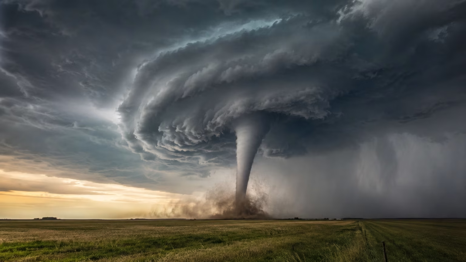

What Is a Tornado and How Does It Form?
A tornado is one of nature’s most dramatic and destructive weather events. It can develop quickly, move unpredictably, and produce winds strong enough to damage buildings, uproot trees, overturn vehicles, and send debris through the air. Yet the visible funnel people associate with a tornado represents only one part of a much larger storm system.
Most tornadoes begin inside powerful thunderstorms where warm, humid air interacts with cooler, drier air. When wind speed and direction change with height, the storm may develop rotation. A strong rising current of air can then tilt that rotation upward and create a spinning column beneath the thunderstorm.
Not every severe thunderstorm produces a tornado, and meteorologists cannot always determine exactly which rotating storm will create one. Tornado formation depends on several atmospheric ingredients coming together in the right place and at the right time. Even small changes in temperature, moisture, wind shear, or storm structure can influence what happens.
Understanding what a tornado is and how it forms can make severe-weather warnings easier to follow. It also helps explain the difference between funnel clouds, supercell thunderstorms, tornado watches, and tornado warnings. Most importantly, this knowledge can help people respond quickly when dangerous weather approaches.
What Is a Tornado?
A tornado is a violently rotating column of air that extends from a thunderstorm to the ground. To be classified as a tornado, the circulation must make contact with the Earth’s surface. A rotating funnel that remains above the ground is generally called a funnel cloud rather than a tornado.
The visible funnel forms when pressure inside the rotating column drops and water vapour condenses into cloud droplets. However, a tornado does not need to have a fully visible funnel. Dust, soil, leaves, and other debris rotating at ground level may reveal that a tornado is present even when condensation is difficult to see.
Tornadoes can vary greatly in width, speed, appearance, and duration. Some are narrow and last only a few minutes, while others become wider, remain on the ground longer, and travel across several communities. Their colour may appear white, grey, brown, red, or nearly black depending on lighting, moisture, and the debris they collect.
Most tornadoes are connected to severe thunderstorms, particularly rotating supercell storms. However, weaker tornadoes can also form from non-supercell storms, developing lines of thunderstorms, tropical cyclones, and rapidly growing clouds near boundaries where winds meet.
What Conditions Are Needed for a Tornado?
Tornado development usually requires warm, moist air near the ground. This air provides energy for a thunderstorm and helps create strong rising currents known as updrafts. The greater the instability in the atmosphere, the more easily warm air can continue rising through cooler air above it.
Cooler, drier air higher in the atmosphere can strengthen that instability. When the warm surface air begins to rise, it cools and condenses into cloud droplets, releasing heat that helps the updraft continue growing. This process can produce a towering cumulonimbus cloud and eventually a severe thunderstorm.
Wind shear is another important ingredient. Wind shear occurs when wind speed, wind direction, or both change at different heights in the atmosphere. Strong wind shear can create horizontal rotation in the air before a tornado-producing thunderstorm has fully developed.
A lifting mechanism is also needed to push warm air upward. Cold fronts, drylines, warm fronts, outflow boundaries, hills, and areas of low pressure can all provide this lift. Tornadoes become more likely when moisture, instability, wind shear, and lift overlap within the same region.
How Does a Tornado Form Step by Step?
Tornado formation often begins when warm, humid air near the surface rises into cooler air above it. As the air rises, it cools and forms a thunderstorm cloud. If the atmosphere contains enough moisture and instability, the cloud can grow rapidly and produce a powerful updraft.
Meanwhile, changing wind speeds and directions at different altitudes can cause air near the ground to rotate horizontally. This spinning air may initially resemble an invisible rolling tube. It is not yet a tornado because its axis is mostly parallel to the ground.
The thunderstorm’s strong updraft can lift and tilt part of this horizontal rotation into a vertical position. As the rising air stretches the rotating column, it may begin to spin faster, much like an ice skater spins faster when pulling in their arms. This rotating updraft is known as a mesocyclone.
If rotation strengthens and extends downward beneath the storm, a lowering called a wall cloud may form. A funnel cloud can then descend from the rotating cloud base. Once the rotating circulation reaches the ground, it becomes a tornado, even if the funnel is not completely visible.
Why Wind Shear Is Essential to Tornado Formation
Wind shear helps organize a thunderstorm and gives it the potential to rotate. Without sufficient wind shear, a storm’s rain-cooled downdraft may fall directly into its updraft. This interference can weaken the storm before long-lasting rotation develops.
When winds change with height, the storm’s updraft and downdraft can remain more separated. The updraft continues drawing in warm, humid air while rain and cooler air fall elsewhere in the storm. This structure allows a severe thunderstorm to survive and strengthen for a longer period.
Changes in wind direction are especially important for creating rotation. Surface winds may blow from one direction while stronger winds several kilometres above the ground blow from another. The resulting shear can create a spinning motion that the storm’s updraft tilts upward.
Wind shear alone cannot produce a tornado. The atmosphere also needs enough instability, moisture, and lift to support a strong thunderstorm. Tornado risk increases when powerful updrafts interact with strong low-level and deep-layer wind shear.
What Is a Supercell Thunderstorm?
A supercell is a highly organized thunderstorm containing a deep, persistent rotating updraft. This rotating region is called a mesocyclone and can be several kilometres wide. Supercells are responsible for many of the strongest and longest-lasting tornadoes.
These storms often have a distinctive structure because the updraft and downdrafts remain separated. The storm may continue receiving warm, moist air for several hours, allowing it to produce large hail, damaging winds, intense rainfall, frequent lightning, and tornadoes.
Meteorologists commonly describe supercells as classic, high-precipitation, or low-precipitation storms. High-precipitation supercells may hide tornadoes behind heavy rain, making them particularly dangerous. Low-precipitation supercells may produce less rain but can still generate large hail and strong tornadoes.
Although supercells are closely associated with tornado formation, most supercells do not produce tornadoes. The storm’s near-ground rotation must become strong, concentrated, and properly positioned. Researchers continue studying why some mesocyclones produce tornadoes while others do not.
What Is a Mesocyclone?
A mesocyclone is a rotating updraft within a severe thunderstorm. It is much larger than the tornado that may eventually form beneath it. Weather radar can often detect this broad rotation before a tornado develops at the surface.
The mesocyclone forms when the storm’s updraft tilts horizontal rotation into a vertical position. As warm air continues rising, the rotating region may become stronger and more organized. This rotation can extend through a significant portion of the thunderstorm.
A mesocyclone should not be confused with a tornado. It may exist several thousand feet above the ground without producing any damaging surface circulation. A tornado develops only when concentrated rotation reaches from the storm toward the surface.
Meteorologists watch mesocyclones closely because strengthening or tightening rotation can signal increasing tornado potential. Radar data, storm-spotter reports, environmental conditions, and visual features are combined to decide whether a tornado warning should be issued.
How Wall Clouds and Funnel Clouds Develop
A wall cloud is a localized lowering beneath the rain-free base of a thunderstorm. It often forms as rain-cooled air wraps around the rotating updraft and is pulled back into the storm. A persistent, rotating wall cloud may indicate that tornado formation is becoming more likely.
Not every wall cloud rotates, and not every rotating wall cloud produces a tornado. Some low clouds can also look like wall clouds from a distance. Meteorologists and trained storm spotters study the cloud’s movement, location, persistence, and relationship to the storm before judging its significance.
A funnel cloud forms when a rotating column beneath the cloud base becomes visible through condensation. The funnel may be narrow and rope-like, broad and cone-shaped, or partially hidden by rain. It may extend downward without making contact with the ground.
Ground contact determines whether the circulation is a tornado. Dust or debris may begin rotating below a funnel before the condensation tube visibly reaches the surface. In that situation, a tornado is already occurring even though a gap appears between the funnel and the ground.
What Is the Difference Between a Funnel Cloud and a Tornado?
A funnel cloud is a rotating cone or column of condensed water droplets that extends from a cloud but does not reach the ground. It may continue developing, weaken, or disappear without ever becoming a tornado.
A tornado is a rotating column of air connected to a thunderstorm and in contact with the surface. Ground contact may be visible through a dust cloud, swirling debris, damaged vegetation, or a complete condensation funnel reaching the Earth.
People should not wait to see a funnel touch the ground before taking shelter. A circulation can already be producing damaging winds at the surface while the visible funnel remains above it. Heavy rain or darkness may also hide the lower portion of a tornado.
Any rotating funnel beneath a severe thunderstorm should be treated seriously. When a tornado warning has been issued, move to a safe location immediately rather than going outside to confirm what the storm looks like.
Different Types of Tornadoes
Supercell tornadoes develop from rotating thunderstorms and include many of the strongest tornadoes. They may remain on the ground longer, grow wider, and travel farther than weaker tornadoes associated with less organized storms.
Landspouts usually form beneath rapidly growing thunderstorms that do not contain a strong mesocyclone. Rotation begins near the ground along a boundary and is stretched upward by the developing cloud. Landspouts are often weaker, but they can still cause injuries and structural damage.
Waterspouts are rotating columns of air over water. Fair-weather waterspouts generally form beneath growing clouds in light-wind conditions, while tornadic waterspouts develop from severe thunderstorms. Waterspouts can move ashore and become dangerous to coastal communities.
Multiple-vortex tornadoes contain two or more smaller rotating areas moving around a common centre. These subvortices can produce narrow paths of extreme damage within the broader tornado track. Their rapid movement can cause neighbouring buildings to experience very different levels of destruction.
Why Some Tornadoes Look Different
Tornado shape is influenced by wind, moisture, pressure, storm structure, and the stage of the tornado’s life cycle. A tornado may begin as a narrow funnel, grow into a wide cone or wedge, and then become thin and twisted as it weakens.
A rope tornado is narrow and often curved, while a stovepipe tornado has a more vertical, tube-like appearance. A wedge tornado appears wider than it is tall from a viewer’s perspective and is often associated with a large circulation, although shape alone does not determine wind speed.
Lighting can make tornadoes appear very different. A tornado illuminated from behind may look dark and threatening, while one viewed with sunlight behind the observer may appear pale. Dust and soil can turn the lower part brown, red, or nearly black.
Rain-wrapped tornadoes may be almost impossible to see. They are common within high-precipitation supercells and can approach without a clearly visible funnel. This is one reason people should rely on official warnings instead of visual confirmation.
How Tornado Strength Is Measured
Tornadoes are commonly rated using the Enhanced Fujita Scale, known as the EF Scale. It ranges from EF0 to EF5 and estimates wind speed based on the damage left behind after the tornado.
Survey teams examine homes, businesses, trees, utility poles, schools, and other structures. They compare the observed damage with known damage indicators and construction quality. The final rating reflects the estimated winds needed to produce that level of destruction.
An EF0 tornado causes relatively light damage, while an EF1 or EF2 tornado can cause increasingly serious structural damage. EF3 tornadoes are considered severe, EF4 tornadoes are devastating, and EF5 tornadoes can destroy well-built structures.
The rating is not based on the tornado’s width, appearance, or how frightening it looked. A powerful tornado crossing open land may receive a lower rating because it did not strike suitable damage indicators. The EF rating therefore describes documented damage rather than a direct wind measurement.
Can Tornado Wind Speeds Be Measured Directly?
Directly measuring wind inside a tornado is extremely difficult. Tornadoes are small compared with large weather systems, move quickly, and create dangerous conditions that can damage or destroy instruments.
Mobile Doppler radar can estimate wind speeds within some tornadoes from a safer distance. However, the radar beam may measure winds above the surface rather than exactly where buildings and people experience the strongest effects.
Special research teams sometimes place instruments in or near a tornado’s expected path. These devices may record pressure, temperature, wind, and other information, but successfully positioning them is difficult because tornado paths can change rapidly.
For most tornadoes, damage assessment remains the main method used to estimate intensity. Researchers combine these surveys with radar observations, videos, photographs, and instrument data to improve understanding of tornado wind fields.
Why Tornado Paths Are Hard to Predict
Meteorologists can identify environments favourable for tornadoes, but predicting the exact path of an individual tornado remains difficult. A tornado may form, turn, strengthen, weaken, or disappear within a short period.
The tornado generally moves with its parent thunderstorm, but local changes in the storm can affect its direction. Interactions with boundaries, nearby storms, terrain, and changes in the rotating updraft may alter the path.
Tornadoes do not always travel in a perfectly straight line. Some curve gradually, shift direction, or briefly lift from the ground before touching down again. A multiple-vortex tornado can also create irregular areas of damage within its main track.
Because paths are uncertain, everyone inside a tornado warning area should take shelter. Assuming the tornado will continue in a straight line or miss a particular neighbourhood can lead to dangerous delays.
Where Do Tornadoes Occur?
Tornadoes have been documented on every continent except Antarctica. They can occur wherever thunderstorms develop in an environment with sufficient instability, moisture, lift, and wind shear.
The central and southern United States experience many tornadoes because warm, humid air from the Gulf of Mexico can meet cooler, drier air from the north and west. Strong winds at different levels of the atmosphere often create favourable conditions for rotating storms.
Tornadoes also occur in Canada, Europe, South America, southern Africa, Australia, Bangladesh, India, Pakistan, and other regions. Some countries experience fewer tornadoes or have less complete reporting, but the risk is not limited to one famous tornado region.
Local building practices, population density, warning systems, and access to shelters influence the human impact. Even a relatively weak tornado can be deadly when it strikes vulnerable homes or catches people without warning.
What Is Tornado Alley?
“Tornado Alley” is an informal term traditionally used for parts of the central United States where tornadoes are relatively common. It often includes portions of Texas, Oklahoma, Kansas, Nebraska, and neighbouring states.
The term does not describe a fixed official boundary. Tornado risk changes from season to season, and significant outbreaks also occur outside the traditional region. The southeastern United States, for example, experiences dangerous tornadoes that are often fast-moving, rain-wrapped, and difficult to see.
Population growth and improved reporting can influence where tornado activity appears most concentrated. Researchers also examine whether patterns are shifting over time, but year-to-year variability remains considerable.
People should understand their local severe-weather risk rather than assuming tornadoes happen only in Tornado Alley. A tornado can occur wherever suitable atmospheric conditions develop, including locations with relatively infrequent events.
When Is Tornado Season?
Tornadoes can occur during any month, although certain seasons are more favourable in different regions. In many parts of the United States, activity increases during spring and early summer as warm, humid air interacts with stronger upper-level winds.
Southern regions may experience a greater risk during cooler months and early spring, while northern areas often see more activity later in spring and summer. Tropical storms and hurricanes can also produce tornadoes during the warmer part of the year.
Tornadoes can form at any hour. Afternoon and early evening are common because daytime heating increases atmospheric instability, but nighttime tornadoes also occur and can be especially dangerous.
Nighttime tornadoes are harder to see, and sleeping residents may miss warnings. Keeping multiple warning methods available, including a charged phone and weather-alert device, can provide important protection.
Does Climate Change Affect Tornadoes?
The relationship between climate change and tornadoes is complex. A warmer atmosphere can hold more moisture and may increase some forms of instability, but tornado development also depends heavily on wind shear and small-scale storm processes.
Reliable tornado records are affected by changes in population, reporting, radar technology, and storm surveys. More weak tornadoes are documented today than in earlier decades, making long-term comparisons challenging.
Researchers have examined changes in the timing, location, and clustering of tornado activity. Some studies suggest that favourable environments or tornado outbreaks may be shifting, but the evidence does not support simple claims that every region will experience more tornadoes.
It is more accurate to say that scientists continue studying how a changing climate may influence severe thunderstorms and tornado-producing environments. Individual tornadoes cannot be attributed to climate change based on appearance or intensity alone.
How Meteorologists Forecast Tornado Risk
Meteorologists begin by studying the wider weather pattern. They examine temperature, humidity, atmospheric pressure, fronts, jet-stream winds, instability, and wind shear to identify areas where severe thunderstorms may develop.
Weather balloons provide measurements from different heights in the atmosphere. Satellites track cloud growth and moisture, while surface stations report temperature, wind, pressure, and humidity near the ground.
Doppler radar allows meteorologists to monitor precipitation and wind movement within storms. Radar can reveal a rotating mesocyclone, tightening circulation, airborne debris, or other patterns associated with a developing tornado.
Forecasting improves when radar observations are combined with reports from trained storm spotters and emergency officials. No single tool provides a complete picture, so meteorologists continually compare multiple sources of information.
Tornado Watch vs Tornado Warning
A tornado watch means atmospheric conditions are favourable for tornadoes and severe thunderstorms. It usually covers a broad area and may remain in effect for several hours. People should review their shelter plan and remain alert for changing weather.
A tornado warning means a tornado has been detected, indicated by radar, or reported by trained observers. The warning normally covers a smaller area because a specific storm presents an immediate danger.
During a watch, charge communication devices, bring outdoor items inside, and identify the safest available shelter. Avoid travelling far from secure buildings when storms are expected to arrive soon.
During a warning, act immediately. Do not spend valuable time opening windows, recording the storm, or waiting for visual confirmation. Move to shelter and continue monitoring official instructions.
Natural Warning Signs of a Tornado
A dark or greenish sky may accompany some severe thunderstorms, although it does not guarantee a tornado. Large hail, intense lightning, sudden wind changes, and a rapidly lowering cloud base can also signal a dangerous storm.
A rotating wall cloud beneath a thunderstorm may indicate increasing tornado potential. People may also see a funnel cloud or a cloud of dust and debris forming near the ground.
Some tornadoes produce a continuous roaring sound that people compare with a train, waterfall, or powerful engine. The sound may become louder as the tornado approaches, but heavy rain and wind can make it difficult to recognize.
Natural warning signs should support, not replace, official alerts. Many tornadoes are hidden by darkness, rain, buildings, or terrain, and some develop too quickly to provide obvious visual clues.
What to Do During a Tornado Warning
Move to a basement, storm shelter, or small interior room on the lowest available floor. Put as many walls as possible between yourself and the outside, and stay away from windows, doors, and large open rooms.
Protect your head and neck with your arms, a helmet, cushions, blankets, or a mattress. Wear sturdy shoes when possible because broken glass, nails, and damaged materials may cover the ground after the storm.
People in mobile homes should leave for a stronger shelter before storms arrive. Mobile homes can be overturned or destroyed even when they are tied down, and remaining inside during a tornado is extremely dangerous.
Drivers should avoid sheltering beneath bridges or motorway overpasses. The safest option is usually to reach a sturdy building. When no building is accessible, follow local emergency guidance and protect yourself from flying debris.
Tornado Safety in Homes and Buildings
A basement generally provides strong protection because it places people below ground level. Stay away from windows and shelter beneath a sturdy table or staircase when the structure allows it.
Without a basement, choose a small interior room such as a bathroom, closet, or hallway. Rooms near the centre of the building are safer than areas along exterior walls.
Avoid gymnasiums, auditoriums, warehouses, and other large open spaces with wide roofs. These structures may collapse more easily because they have fewer interior supports.
In schools, offices, and public buildings, follow the established emergency plan. Move quickly but calmly, remain with the group, and protect your head until officials confirm that the danger has passed.
Common Tornado Myths
Opening windows does not protect a house from a tornado. It wastes valuable time and may expose people to broken glass and flying debris. Structural damage results mainly from extreme winds and debris rather than trapped indoor pressure.
Tornadoes can cross rivers, lakes, hills, cities, and motorways. Terrain may influence local airflow, but no ordinary landscape feature creates reliable protection from a strong tornado.
Highway overpasses are not safe tornado shelters. Wind may accelerate through the narrow space, while debris can strike people who have little protection. Stopped vehicles can also block roads needed by emergency responders.
Tornadoes do not always move from southwest to northeast. While many follow a general path influenced by the parent storm, they can travel in different directions and change course unexpectedly.
What Happens After a Tornado?
After the storm passes, continue monitoring official information because additional tornadoes or severe thunderstorms may be nearby. Do not leave shelter until the warning has expired or emergency officials say it is safe.
Watch for fallen power lines, gas leaks, unstable walls, broken glass, sharp metal, and damaged trees. Use a flashlight rather than candles if a gas leak may be present.
Check yourself and others for injuries, but avoid moving seriously injured people unless they face immediate danger. Contact emergency services and provide first aid within your level of training.
Avoid entering heavily damaged buildings until authorities have inspected them. Photograph damage only when it is safe, communicate by text when phone networks are overloaded, and follow local instructions about evacuation and recovery.
Why Understanding Tornadoes Matters
A tornado is a rotating column of air that connects a thunderstorm with the ground. It develops when atmospheric instability, moisture, lift, and wind shear support a strong rotating updraft.
Many powerful tornadoes form from supercell thunderstorms containing mesocyclones. Rotation may tighten beneath a wall cloud, produce a funnel, and eventually reach the ground as a tornado.
Forecasting technology can identify dangerous environments and detect storm rotation, but the exact timing and path of a tornado remain difficult to predict. This uncertainty makes official watches and warnings essential.
The most useful tornado knowledge leads to action. Knowing where to shelter, how to protect your head, and when to respond can reduce the risk of injury during one of nature’s fastest-developing hazards.
Frequently Asked Questions
How does a tornado start?
A tornado may begin when wind shear creates horizontal rotation and a strong thunderstorm updraft tilts it vertically. The rotation can tighten and extend downward until it reaches the ground.
Can a tornado form without a supercell?
Yes. Landspouts and some weaker tornadoes can develop from non-supercell thunderstorms. However, many strong and long-lasting tornadoes form from rotating supercells.
How long does a tornado usually last?
Many tornadoes remain on the ground for only a few minutes, but some can last much longer. Duration depends on the storm’s structure, environment, and ability to maintain rotation.
What is the strongest type of tornado?
EF5 is the highest rating on the Enhanced Fujita Scale. It represents devastating damage associated with extremely intense estimated winds, although EF5 tornadoes are rare.
Is a funnel cloud always dangerous?
A funnel cloud may never touch the ground, but it can develop into a tornado quickly. People should follow official warnings and seek shelter rather than watching it from outside.